Wade`s Causeway. A Roman Road?

A colour photo showing a line of kerbstones - there is short grass on the right hand side, and much thick tussock grasss on the left - in the distance there is a small single-story building on the horizon, and a fence line leading away to the left
Figure 4 – The kerbstones edging Wade’s Causeway

Back to Main Blog Page

Three hundred years ago it was suggested that a Roman road – Wade’s Causeway – ran from Amotherby over the Vale of Pickering and the North Yorkshire Moors towards the coast. There is also a long-held view that this military way traversed Fort D at Cawthorn and then descended from the escarpment, on which the Roman earthworks sit, to the valley of the Sutherland beck

In 1817 Rev. George Young, a local pastor wrote a ten-page description of Wade’s Causeway in his ‘History of Whitby‘ clearly describing the onward route between Cawthorn and the Roman Fort at Lease Rigg. But he also commented how ‘it is almost enough to break the heart of an antiquary, to see a monument that has withstood the ravages of time for sixteen centuries wantonly destroyed‘ to build banks or to repair ‘contemptible by-roads‘.

A colour photo showing stoney ground heading away across a stretch of moorland
Figure 1 – view of the possible Roman road crossing Wheeldale Moor

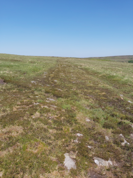
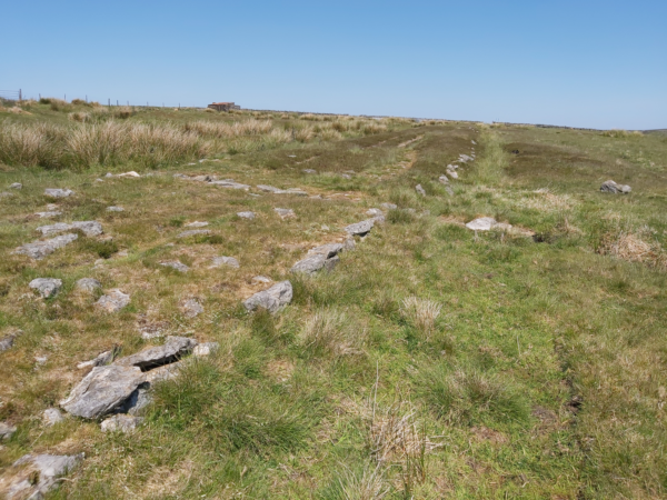
Nowadays a surviving one-mile stretch of this structure can easily be followed across Wheeldale Moor. It consists of flagstones seated on a cambered base of soil, clay, peat, gravel and loose pebbles forming a raised embankment varying between 5.4 and 6.7 metres wide. It is also crossed by a dozen small culverts and, in some parts, edged with kerbstones of upright slabs (Figure 1).

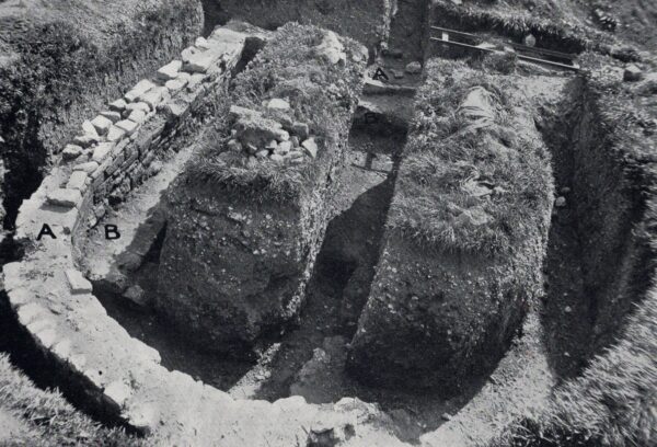
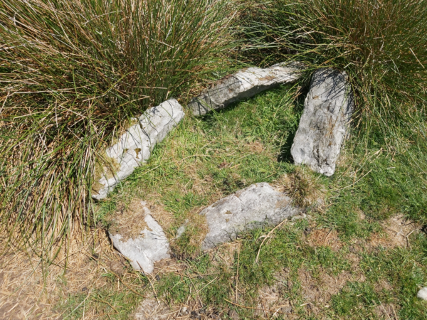
But is it really Roman? Some archaeologists have suggested that it could be a medieval road or a more ancient boundary feature. Aside from some pottery no Roman objects have been found on or near the structure across Wheeldale Moor. Also, a stone burial cist set into one side of the monument most likely pre-dates the Roman occupation (Figure 2).

A colour photo showing five roughly rectangular stones set in a irregular pattern to form a burial cist - there are also some large clumps of tussock grass at the top edge of this cist
Figure 2 – stone burial cist alongside Wade’s Causeway

Others have expressed concerns that it might have been ‘Romanised’ and ‘re-constructed’ by a local gamekeeper, James Patterson, who removed the peat thereby revealing the stones at the beginning of the last century. However, a careful assessment of Wade’s Causeway by Hayes and Rutter in 1964 concluded that it was a Roman road based on the following key findings:

A series of large stones set into dry grassy ground - these resemble stepping stones
Figure 3 – sandstone slabs forming part of Wade’s Causeway
  • The raised and cambered embankment (agger), providing a well-drained road foundation
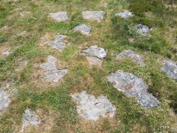
  • The substantial layer of rough sandstone slabs (Figure 3)
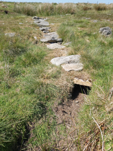
  • The kerbstones (Figure 4)
  • The evidence of a surface layer of gravel
A colour photo showing a line of kerbstones - there is short grass on the right hand side, and much thick tussock grasss on the left - in the distance there is a small single-story building on the horizon, and a fence line leading away to the left
Figure 4 – The kerbstones edging Wade’s Causeway

Also, a century before James Patterson’s work, Rev. George Young wrote that ‘the foundation is usually a stratum of gravel or rubbish, over which is a strong pavement of stones, placed with their flattest side uppermost, and above these another stratum of gravel or earth to fill up the interstices, and smooth the surface. To keep the road dry, the middle part has been made higher than the sides; and, to prevent the sides from giving way, they are secured by a border of flat stones placed edgewise’.

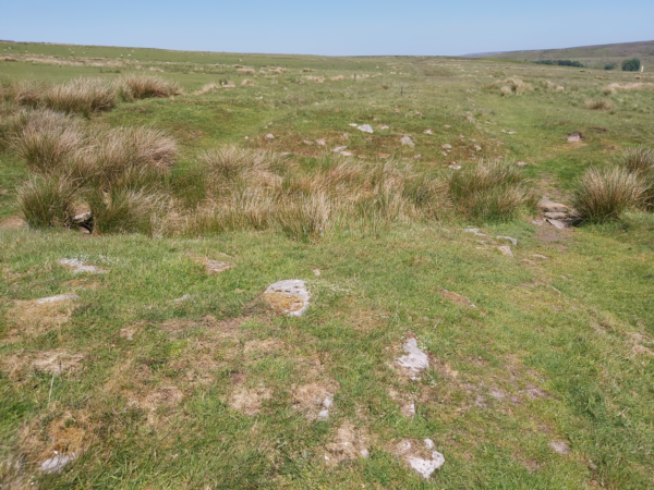
Admittedly some of the culverts crossing the road appear modern as do the ditches running alongside (Figure 5). There are also occasional ‘gaps’ where the structure crosses several streams but, perhaps, the gently rising banks at such locations originally bore wooden bridges (Figure 6).

A culvert running along the grassland of Wheeldale Moor, capped with large stones - parts of this culvert have collapsed slightly - at the top there are lots of large clumps of tussock grass
Figure 5 – Culvert on Wade’s Causeway

Finally, if the monument on Wheeldale Moor is, indeed, Roman then was it constructed as a component of the early military campaigns across the North and/or to facilitate troop movements between Malton Fort and the coastal fortlets in the fourth century? There is no clear answer to this, and it has even been suggested that it was used by jet traders too.

A colour photo showing a large area of grassland on Wheeldale Moor - a hollow patch with tussocks grass growing within it in cuts across this photo - on either side there are some large stones visible through the dry grass - on the far side there is a clearly defined rectangular area of dry grass
Figure 6 – Suggested location for a wooden bridge on Wade’s Causeway

Wade’s Causeway is an intriguing monument and considerable controversy still shrouds its origin and purpose. Local legend also tells of a giant named Wade who once lived in the area. He is said to have built the road for his wife, Bell, to herd her sheep along en route to the moorland pastures or to market.

Back to Main Blog Page


For more information on Wade’s Causeway visit: Wikishire.co.uk


Figure 1: View of the possible Roman road crossing Wheeldale Moor ©Nick Summerton

Figure 2: Stone burial cist set into the side of the possible Roman road crossing Wheeldale Moor ©Nick Summerton

Figure 3: Sandstone slabs on the possible Roman road crossing Wheeldale Moor ©Nick Summerton

Figure 4: The kerbstones edging the possible Roman road crossing Wheeldale Moor ©Nick Summerton

Figure 5: Culvert on the possible Roman road crossing Wheeldale Moor ©Nick Summerton

Figure 6: Suggested location for a wooden bridge on the possible Roman road crossing Wheeldale Moor ©Nick Summerton


Have you seen our other blogs?

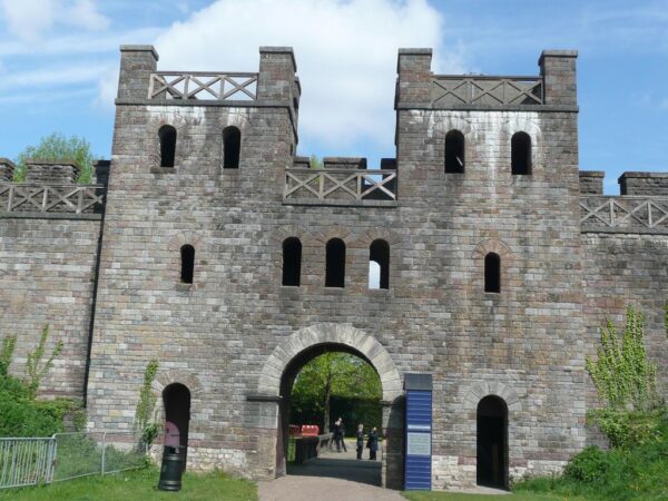
https://www.maltonmuseum.co.uk/2021/04/17/the-romans-at-cawthorn/

https://www.maltonmuseum.co.uk/2021/03/06/petillius-cerialis-and-the-brigantes/

https://www.maltonmuseum.co.uk/2021/05/29/the-fortlets-signal-stations-along-the-yorkshire-coast/

https://www.maltonmuseum.co.uk/2021/02/20/roman-jet-and-the-malton-bear/

Malton Roman Fort

A greyscale plan orientated North with a extract from a geophysical survey overlain onto a map of Malton - this shows a very concentrated arrangement of earth ramparts, ditches, and roads - this plan also shows street names such as Old Maltongate, and buildings such as The Lodge, and includes an illustration and label marking a 'Dismantled Railway' along the North side
Figure 5: Interpretation of geophysical survey data from Malton Fort

Back to Main Blog Page

Orchard Fields is regularly used by locals and visitors, and although it does have some impressive earthworks, most people would find it hard to know how Malton Roman Fort was laid out, read on to find out more.

When Petillius Cerialis first arrived in Malton it is most likely that he constructed a tented temporary camp of around 22 acres to accommodate the troops of the 9th legion. [See Malton blog: https://www.maltonmuseum.co.uk/2021/03/06/petillius-cerialis-and-the-brigantes/]

What is still visible today – in Orchard Fields – are the remains of the defences of an 8.5-acre fort that was originally built in timber at around AD 79 during the governorship of Agricola. It is strategically very well-placed affording extensive views over the Wolds, and, on a clear day, it is still possible to see Seamer Beacon (a probable Roman site) just west of Scarborough.

The timber fort would have had a 5-metre-high walkway and was surrounded by a single ditch. Twenty-five years later the ramparts were rebuilt in stone with new double ditches being dug further out from the walls while the original inner ditch was back filled.

A greyscale plan of Malton Fort showing extensive detail of how this site was laid out - this plan also includes buildings that were there during excavation in the 1920's
Figure 1 – Philip Corder`s 1920s plan of Malton Fort

Figure 1 is a plan of Malton Roman Fort drawn by the archaeologist, Philip Corder, following his series of excavations in the 1920s. A contemporary photograph along trench 5 on the plan (Figure 2) clearly shows the stone north-east wall (in the centre of the picture) with the ditches further out towards the railway.

A black and white photo showing a neatly dug, deep trench containing substantial stone walls that intersect this trench - there is an extensive spoil heap on the left hand side, and much small collections of stone of the right hand side - there is also a measuring sticks in the foreground, and another about halfway along the trench - three men can be seen within the trenches, and in the background there is a fence-line along either side of the railway line
Figure 2: Trench 5 looking north-east

In common with most Roman forts Malton conformed to the classic playing card shape: a rectangle with rounded corners. It also had four entrances with the main gate (porta praetoria) being within the south-west rampart of the fort, enjoying road connections with York, Brough and Stamford Bridge. At the opposite side of the fort was the back gate (via decumana) leading to Hovingham and Whitby.

Two roads were central to the internal layout of any Roman fort. The via praetoria ran north-west from the main gate to join the via principalis in front of the headquarters building (principia). At either end of this were two further gates – the porta principalis sinistra and the porta principalis dextra – leading to Scarborough/Filey and York/Aldborough respectively.

A colour photo showing a solid looking wooden gatehouse with two stairways on either side leading onto a platform above the gateway - alongside this there are planted borders - a palisades walkway runs on eiother side of this platform - there are also ladders that lead to a second platform above this - in the foreground there is short mown grass and various street furniture including a display board and various fencing
Figure 3: Reconstructed wooden gate at Lunt
A colour photo showing a large stone built gatehouse with a main entrance gate, plus two much smaller side gates - above this there is a level with three central windows, and two slightly smaller window that mirror the positions as described previously - above this is another level that links to a palisade walkway - and finally above this are two towers on either side of the main gate with another platform placed at the top of each tower - there is also a variety of street furniture such as litter bins, fences and signage
Figure 4: The North Gate of Cardiff Castle

The porta principalis sinistra (North-East Gate) was carefully excavated by Philip Corder in the 1920s. Originally it was a double portal wooden structure similar to the modern example that can be viewed at Lunt (Nr Coventry) (Figure 3). When the fort walls were rebuilt in stone this entrance was reformed as single inner and outer arches accommodating a central chamber flanked by two guard rooms. A good reconstruction showing what the first stone structure might have looked like can be seen at Cardiff Castle (Figure 4). Subsequently this gate went through several further modifications possibly including repairs by the rebel Emperor Carausius. [See Malton blog: https://www.maltonmuseum.co.uk/2021/01/11/carausius/ ]

A greyscale plan orientated North with a extract from a geophysical survey overlain onto a map of Malton - this shows a very concentrated arrangement of earth ramparts, ditches, and roads - this plan also shows street names such as Old Maltongate, and buildings such as The Lodge, and includes an illustration and label marking a 'Dismantled Railway' along the North side
Figure 5: Interpretation of geophysical survey data from Malton Fort
A black and white photo showing the horseshoe shaped wall of an apsidal building and within this is a rectangular shaped earlier building - within this are two mounds of earth with a neatly cut trench running through it - there are a couple of pieces of archaeological equipment on the top left hand side that look like a folded up canvas and a wooden framework
Figure 6: Apsidal building (A), showing earlier rectangular building (B) beneath

To date little digging has taken place inside the fort but geophysical surveys have identified probable barrack blocks, workshops, stores and granaries in addition to the principia (Figure 5). However, some limited excavations just inside the north-east wall of the fort in the 1920s found an oven and a late Roman building with an apse (Figure 6). Whether this apsidal structure was a domestic building, a public building or an early church remains uncertain.

Back to Main Blog Page


For more information and guided tours around Orchard Fields please check out the Malton Museum website:

https://www.maltonmuseum.co.uk/online-booking/


Find out how to find Malton Roman Fort from:

Historic England and Ancient Monuments


Figure 1: Philip Corder`s 1920s plan of Malton Fort based on his excavations

Figure 2: Trench 5 looking north-east showing the stone north-east wall (in the centre of the picture) with the ditches (marked by the three men) further out towards to railway ©Malton Museum

Figure 3: Reconstructed wooden gate at Lunt ©Creative Commons

Figure 4: The North Gate of Cardiff Castle reconstructed in Roman style ©Creative Commons

Figure 5: Interpretation of geophysical survey data from Malton Fort ©TJ Horsley

Figure 6: Apsidal building (A), showing earlier rectangular building (B) beneath ©Malton Museum