The Romans at Cawthorn

An aerial colour photograph showing a square of dry heathland with rounded corners (Ford D)- there is a perimeter path as well as two paths that link to a central crossroads dividing the site into quarters - there is is also an opening onto a further irregular area of scrub to the top left (Camp C)- both sites are surrounded by dense woodland
Figure 2 – Overview of Fort D and Camp C looking south

Back to Main Blog Page

Cawthorn Camps is a fascinating – and enigmatic – site with the remains of a Roman camp in addition to two Roman forts, one of which had an annex. The earthen ramparts and gates are particularly well preserved.

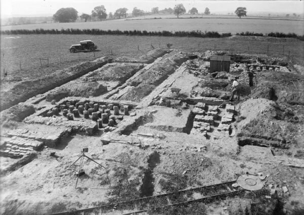
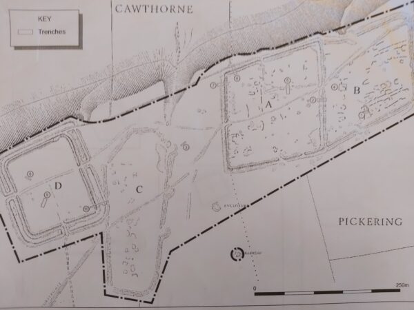
During the 1920s it was excavated by the eminent archaeologist Sir Ian Richmond and his colleagues. He proposed that the earthworks had been constructed for training purposes between the late 1st century and the early 2nd century. But more recent work by Graham Lee and Pete Wilson has led to a reassessment of Cawthorn (Figure 1). It is now considered that it was an integral component of the Roman occupation of Yorkshire involving several building phases over a period of around 40 years.

A greyscale illustration of Cawthorn Camps showing a steep bank to the northern edge - there is a perimeter line highlighting the extent of these excavations - the site is in excess of 750m in length from South West to North East - each excavation is similar in size - these are labelled from West to East as follows: site D (square), site C (coffin-shaped), site A (rhombus), and site B (irregular rhombus)
Figure 1 – Plan of Cawthorn Camps showing recent excavation trenches

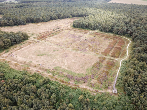
It is suggested that the first military structure constructed by the Roman forces was a temporary fort (D) (Figure 2). This would have been a rectangular enclosure with rounded corners and surrounded by a single ditch. Such forts typically had a headquarters building (principia) in the centre, flanked by a house for the commander (praetorium) on one side and one or more granaries (horrea) on the other. Most of the rest of the fort’s interior would have been taken up with ordered rows of barrack blocks.

An aerial colour photograph showing a square of dry heathland with rounded corners (Ford D)- there is a perimeter path as well as two paths that link to a central crossroads dividing the site into quarters - there is is also an opening onto a further irregular area of scrub to the top left (Camp C)- both sites are surrounded by dense woodland
Figure 2 – Overview of Fort D and Camp C looking south

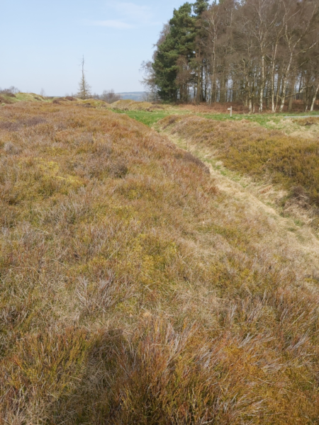
Some years later a re-occupation of (D) entailed digging an outer Punic ditch (Figure 3). This was constructed with a gently sloping inner wall and a steep outer wall: easy to jump in but tricky to get out! Importantly these two periods of use (probably around AD 80 and AD 120) match those for the fort at Lease Rigg a few miles north.

A colour photo from Cawthorn Camps showing a narrow path through thick grass, linking to another path at a crossroad - there are mature trees in the top right, and a waymarker that highlights the photos large scale
Figure 3 – The Punic ditch of Fort D

Roman camps had no fixed internal structures with troops being accommodated in tents. They were only occupied for a few days or weeks with the perimeter defences being less substantial in comparison with forts and topped with a row of sharpened stakes.

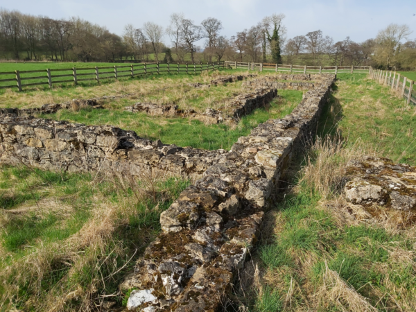
The camp at Cawthorn (C) is surrounded by a coffin shaped rampart and three clavicula-type gates can still be clearly seen (Figure 4). Claviculae were designed to force attackers to pass through the gateway sideways with their sword-arms exposed. There were various types of camp and (C) was probably a construction camp linked to the building of another temporary fort (A) to the east. The lack of any gates on the west side of the camp might relate to a continuing occupation of fort (D) when the camp was established. However, the second outer ditch of fort (D) broke through the defences of this camp, indicating that, by then, the camp had been abandoned.

A colour photo from Cawthorn Camps showing a narrow winding path through an area of rough heathland, with thick grass, heather, and gorse - along the top egde there is a band of mature trees that then leads into the distance at the right hand side
Figure 4 – A clavicula-type gate of Camp C

Fort A was a substantial structure with a deep ditch (4.5 metres X 2.1 metres) and double claviculae. The 1930s excavations identified post holes and some vestiges of timber ramparts in addition to the possible remains of a platform for a ballista in the south east corner. Also, a prehistoric burial mound in the centre of the fort might have been remodelled by the Romans into a tribunal, from which senior officers could have addressed the troops.

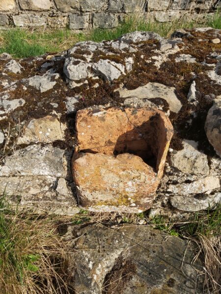
Many Roman forts had attached annexes providing additional space for storage and accommodation (particularly for goods, animals and troops in transit) in addition to facilities such as workshops. At Cawthorn it seems highly likely that the earthworks east of fort (A) served as such an annex (B). There is also evidence for stone ovens and hearths in addition to turf-built structures linked to the Roman occupation within both fort (A) and annex (B).

Today Cawthorn still puzzles many historians and archaeologists. Questions remain about the routes followed by the troops to and from the site as well as the reason for choosing a location with such a poor water supply. There have also been few finds with no coins and only a minimal amount of pottery being unearthed. But it is important to appreciate that a Roman army on campaign made particular use of metal vessels – paterae – for cooking and eating. A fine example of a patera is Lucius’ Pan which has been marked with its owners name, hence Lucius, this is often on display at Malton Museum.

Back to Main Blog Page


As part of our new range of tours this year, Malton Museum will be offering visits around Beadlam Villa and Cawthorn Roman Camps. Look out for details on social media, our website and in the local press. Both tours will be led by our ‘Blogger’ Nick Summerton.


Figure 1: Plan of Cawthorn Camps showing recent excavation trenches ©English Heritage

Figure 2: Overview of Fort D and Camp C looking south ©English Heritage

Figure 3: The Punic ditch of Fort D ©Nick Summerton

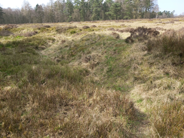
Figure 4: A clavicula-type gate of Camp C ©Nick Summerton


Find out more about Cawthorn Camps from

North York Moors, National Park

Historic England

Britain Express

The Roman Villas around Malton and Norton

A colour photo showing extensive walls from Beadlam Villa surrounded by a wooden fence - some sections of wall are complete up to a fourth course - there is rough grass within and immeditely around these ruins - beyond this fencing there is well maintained grass bank area surrounded by trees
Figure 3 – Overview of the villa at Beadlam

Back to Main Blog Page

It might be a surprise to you just how many Roman villas there are around Malton and Norton – do you know which features define a Roman building as a villa…?

To Pliny the Younger, writing in the 1st Century AD, the Latin word ‘villa’ simply meant a country house where he could escape from the hustle and bustle of the city. But ancient East Yorkshire was a long way – both geographically and culturally – from Italy so we need to tread carefully in using the term ‘villa’ to describe Roman structures that might be unearthed within the local countryside.

Professor Martin Millett has proposed that – in Britain – rural buildings might be classified as villas if they are rectangular in plan, make use of stone, have solid floors (sometimes with mosaics) in addition to hypocausts and baths. Using these criteria, it seems that at least twenty-one Roman villas can be identified within a 30km radius around Malton (and a dozen within 20km) including examples at Hovingham, Langton and Beadlam.

A greyscale copy of a report containing plan drawings, an introduction, and a description with a key to numbered elements within these plan drawings
Figure 1 – The 1745 report of the finds at Hovingham

During the construction of ornamental gardens, streams and fish-ponds at Hovingham Hall in 1745 the remains of a Roman bath-suite were found complete with hypocausts (Figure 1) . Some 74 metres west of this structure another building was unearthed containing a mosaic floor and, more recently, a Ground Penetrating Radar (GPR) survey has identified a further rectangular building, 45 metres by 23 metres.

A black and white photo showing a complex of archaeological features - there is also a car parked nearby which gives the photo a reference to its 1930's origin - also in the foreground there is also the end of a narrow gauge railway track
Figure 2 – Overview of the excavations at Langton

At Langton at least two Roman villas existed and the one located east of the village was comprehensively excavated in the 1930s. A particularly significant discovery was the remains of a building termed a ‘dwelling house’ with hypocausts and the vestiges of a mosaic pavement (Figure 2). A small bath house was also found 55 metres further east.

A colour photo showing extensive walls from Beadlam Villa surrounded by a wooden fence - some sections of wall are complete up to a fourth course - there is rough grass within and immeditely around these ruins - beyond this fencing there is well maintained grass bank area surrounded by trees
Figure 3 – Overview of the villa at Beadlam

The villa at Beadlam is the only local example where the walls are still exposed above ground (Figures 3 & 4). It was discovered in 1964 by ploughing and then carefully examined over the subsequent 15 years. Important finds include mosaics (possibly made by the same individual as the example at Hovingham), wall plaster, channelled hypocausts and wall heating flues in addition to the remains of a large number of glass drinking vessels.

A colour photo showing a largely complete terracotta box flue section- this is inset into a stone wall - there is rough grass in both the foreground and background - another more complete wall can be seen behind this section of ruined wall
Figure 4 – Box flue tile in the wall of the heated mosaic room at Beadlam

Beadlam is a complicated structure with three main ranges – north, east and west – and eleven distinct buildings. The northern section is visible today and, although the mosaic discovered there has been moved to storage in Helmsley, it is a splendid site to visit (Figure 5). A bathhouse was also found at the end of the west wing and this area can still be detected as an earthwork.

A section of Roman mosaic with a guilloche pattern: this pattern resembles platted strings or woven willow - in this example each strand has three light coloured stirpes between two dark coloured stripes, giving it a strong visual impact
Figure 5 – The edging of the mosaic at Beadlam

In common with the Langton dwelling house, the north range at Beadlam was fronted by a veranda and it seems likely that both buildings had upper stories too. They were probably mixed farms with a considerable quantity of animal bones being found at Langton and possible stock yards at Beadlam. There were also corn-drying ovens and Beadlam boasted a small mill too. Many villas were not simply agricultural establishments and often accommodated other manufacturing and processing activities. Two large hoards of iron tools have been unearthed at Beadlam and there was metal working taking place at Langton.

At both Langton and Beadlam there is archaeological evidence of structures that existed prior to the villas being built, suggesting that the occupants may have been Romanised locals. The finding of bronze writing styli implies that they might have been literate too. It is quite conceivable that such individuals could have held positions of importance in Malton where they also took their produce to market. However, it is important to appreciate that, across Britain, many villa residents would have been tenants while some owners were not British or even lived in Britain.

Based on the coin, glass and pottery finds at Hovingham, Langton and Beadlam it is clear that they were all occupied from the mid second century until well into the late 4th or early 5th centuries. This prolonged period of use – with many of the embellishments to the living accommodation taking place in the 4th century – perhaps reflects confidence in the security provided by the troops at Malton and the signal stations along the coast. Interestingly a cavalry spur and a Roman military strap end have been found at Beadlam.

As part of our new range of tours this year, Malton Museum will be offering visits around Beadlam Villa and Cawthorn Roman Camps. Look out for details on social media, our website and in the local press. Both tours will be led by our ‘Blogger’ Nick Summerton.

Back to Main Blog Page


Figure 1: The 1745 report of the finds at Hovingham ©Sir William Worsley

Figure 2: Overview of the excavations at Langton ©Malton Museum


Figure 3: The edging of the mosaic at Beadlam ©English Heritage

Figure 4: Box flue tile in the wall of the heated mosaic room at Beadlam ©Nick Summerton

Figure 5: Overview of the villa at Beadlam ©Nick Summerton

Find out more about Beadlam on wikipedia: wikipedia